Tropical Storm Hanna Update - NEC Coop
Jul 24, 2020 — News
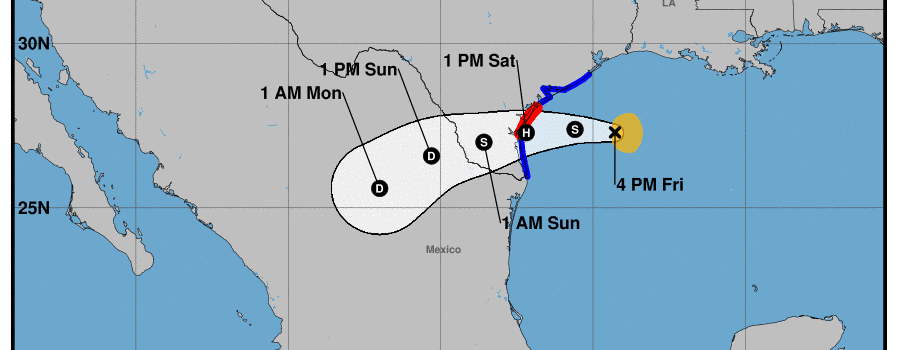
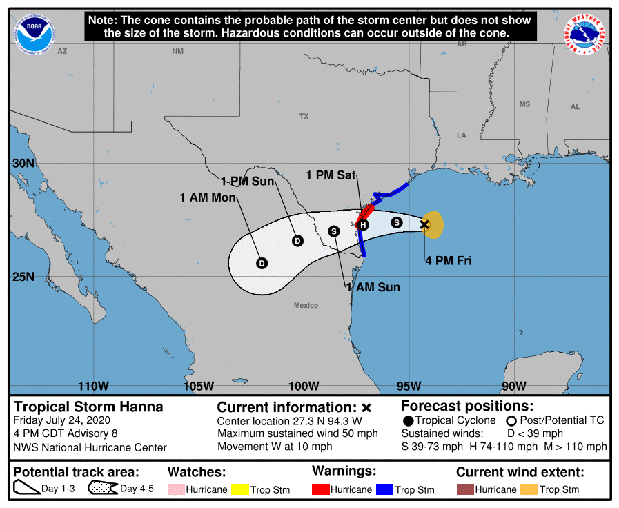
7/24/20, 4:00 p.m.
Tropical Storm Hanna continues to strengthen and will move west across the northwestern Gulf of Mexico through Saturday. Hanna is currently forecast to make landfall along the South Texas coast as a Category 1 Hurricane Saturday afternoon. There still remains uncertainty regarding the exact landfall location. Heavy rain is expected to occur beginning tonight and continuing through Sunday. Due to the slow movement of Hanna, rainfall could be significant and dangerous flooding may result. The approach of Hanna will also result in minor to moderate coastal flooding of area beaches, bays, and intracoastal waterways of the Middle Texas Coast, and in an increased threat for dangerous rip currents. Isolated tornadoes will also be possible on Saturday. Residents of South Texas are strongly urged to monitor this system and take appropriate actions. Winds of this strength can cause widespread and extended power outages. In addition, Hanna is expected to bring heavy rainfall with flash flooding likely.
Electricity Company in Texas, NEC Co-op Energy Members are reminded to follow these safety tips:
- Stay away from downed power lines and report the situation to 911
- Turn around, don’t drown when confronted with high or rising water
- Whole house/circuit generators should be connected by a licensed electrician and transfer switches installed to protect line workers who may be working to restore power from back fed electricity. Stand alone generators should be properly ventilated and connected directly to appliances.
- Be prepared visit ready.gov for preparedness information
- Report outages to your delivery company
Voted #1 Electric Provider
We were recently voted the #1 Electricity Provider by the Corpus Christi Caller-Times’ Best of the Best Awards for the 7th year running!
Benefits of Membership
As a member of our co-op, you’ll enjoy the following benefits:
- You’ll get a share of our profits.
- You won’t be locked into a long-term contract.
- You’ll get a simple, competitive rate with no surprise fees or markups.
- You can get a $50 bill credit for every new member you refer.